
Weather Stations Near Me: Find the Best Local Observation
Use the right map for current personal-station data, official airport observations, or historical records—and learn why the closest marker is not always the best match.
What do you want to find?
Current conditions
Hyperlocal observations
Start with a personal-station map, then check timestamp, elevation, exposure, and quality flags.
Official report
Airport observations
ASOS/AWOS stations report standardized aviation observations, often at an airport rather than your neighborhood.
Yesterday / history
Climate records
Use NOAA/NCEI tools to identify official stations and retrieve archived datasets.
Backyard network
Personal station nearby
Weather Underground, PWSWeather, WeatherLink, and other ecosystems can show privately operated stations.
Reliable station-finding tools
| Tool | Best use | What to check | Limit |
|---|---|---|---|
| NOAA/NCEI Find a Station | Official historical/climate stations and datasets. | Dataset, reporting period, date coverage, station identifier, distance. | The nearest station may not have the variable or period you need. |
| NOAA MADIS Surface Viewer | Surface observations from multiple networks. | Station type, timestamp, units, quality-control information, coordinates. | The interface is technical and network coverage varies. |
| Weather Underground map | Hyperlocal personal-station conditions. | Freshness, station history, nearby-station agreement, siting clues. | Private stations vary in placement and maintenance. |
| PWSWeather map | Personal, METAR, and MADIS stations on one map. | Network/source label and observation time. | Not every station reports every variable. |
| WeatherLink map | Public Davis WeatherLink stations. | Public status, timestamp, sensor availability. | Only stations shared through that ecosystem appear. |
| Tempest map | Public WeatherFlow/Tempest observations. | Time, location, measurement context. | Coverage depends on public sharing and local ownership. |
Find the best nearby observation in five steps
Search
Enter your address, ZIP code, city, or map location.
Identify
Note station ID, network, coordinates, and elevation.
Check time
Discard stale or intermittently reporting observations.
Compare
Use two or three nearby stations, not one isolated value.
Choose
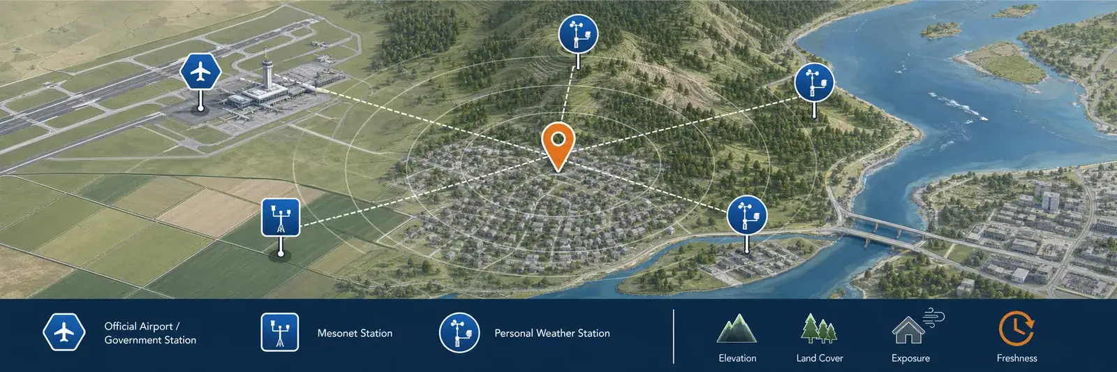
Prefer representative terrain and exposure over distance alone.
Why the closest station can be wrong for your question
Higher or lower terrain
Temperature, precipitation type, wind, and pressure context can change with elevation even over a short distance.
Airport, city, field, or water
An airport field, dense neighborhood, irrigated yard, coastline, or valley can represent a different microclimate.
Roofs, trees, and pavement
Poor placement can bias a personal station. Look for agreement with surrounding stations and realistic changes over time.
Old data can look current
Always read the observation time. A station can remain on a map after its uploads become intermittent.
Not every station measures everything
A location may report temperature but not rainfall, wind, snow, UV, air quality, or a full history.
Networks treat data differently
Some systems apply automated checks or suppress suspicious values. A map marker alone does not prove research-grade quality.
Compare two or three stations before choosing one
Open several nearby observations and compare the same timestamp, not just the latest number shown on each map. Check elevation, terrain, distance from water, urban development, and whether the station sits on a roof, at an airport, in an open field, or in a sheltered backyard. A station five miles away at a similar elevation may describe your conditions better than one a mile away on a ridge or beside a large paved area.
Look at the pattern over several hours. If temperature, humidity, pressure, and wind direction move together while one station remains consistently different, the difference may be a real microclimate—or it may point to siting, maintenance, units, or timestamp problems. Rainfall is especially local, so compare radar and several gauges rather than assuming one nearby total applies to your property.
Check station status before saving a result. Note the observation time, reporting interval, and whether the map flags the station as offline or quality-controlled. A stale station can remain visible after it stops updating, and a daily high or low may be incomplete if the service resets on a different time zone. Save the station identifier and source with any value you plan to cite later.
Find yesterday’s high, low, or historical weather
If your real question is “How hot was it yesterday?” or “What was last night’s low?”, select a station with an archive rather than relying on a current-conditions map.
- Use NOAA/NCEI to identify a station and dataset with the required date range.
- Confirm whether the value is a calendar-day maximum/minimum, an hourly observation, or a different reporting period.
- Check units, time zone, observation-day convention, and missing-data flags.
- Record the station ID so you can use the same reference later.
- For a personal station, confirm that its history is complete and that the station did not move.
FAQ
How do I find the nearest official weather station?
Use NOAA/NCEI’s Find a Station tool for U.S. climate stations and datasets, or identify nearby airport ASOS/AWOS sites. Choose by station type, period of record, elevation, and available variables—not distance alone.
How do I find a personal weather station near me?
Open a public PWS map such as Weather Underground, PWSWeather, WeatherLink, or Tempest, zoom to your location, and inspect the station timestamp and metadata. Compare several nearby stations before trusting one.
Why does a nearby station show a different temperature?
Elevation, shade, ground cover, buildings, water, wind exposure, sensor height, calibration, and observation time can all create real or artificial differences.
Can I use a nearby personal station for official records?
Use the record source required for your purpose. Insurance, legal, agricultural, aviation, and research uses may require an official dataset or documented station standard. A public PWS map is useful but is not automatically an official record.
Sources and further reading
These official and network references explain where station observations come from and how to evaluate the data you find.
NOAA/NCEI station map FAQ — Official help for finding stations and climate data.
NOAA MADIS surface observation dump — Public access to integrated surface weather observations.
Weather Underground data sources — Explanation of Weather Underground observation sources.
Aviation Weather Center METAR data — Official airport surface observations and station lookup.