
Weather radar field guide
Why Does Weather Radar Show Rings, Circles, and Spokes?
A neat circle on your radar app may not match the rain gauge in your yard. Learn how to distinguish bird rings, melting snow, storm boundaries, and display effects before deciding what the colors mean.
Quick answer
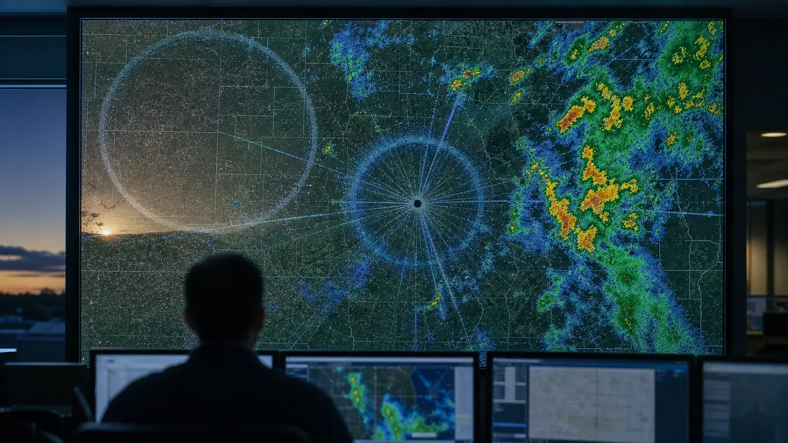
Weather radar rings have several causes. A small ring expanding from a bird roost near sunrise differs from a ring centered on the radar, which may come from melting snow aloft, sampling effects, or a distance overlay. A storm can also produce an expanding outflow arc. Narrow spokes may be interference, but some storm-related artifacts accompany hail. Check the center, time, product, and motion together. A circle alone cannot tell you whether rain is reaching your yard.
Start with three checks in your radar app
- Read the product name and scan time. Start with observed reflectivity, rather than a future-radar animation or rainfall-total layer. Check whether the most recent scan is actually current. If your app offers it, use one radar site and its lowest available elevation angle before comparing a national mosaic.
- Find the radar location and turn off optional overlays. Your location dot is not necessarily the radar. Distance circles, coverage outlines, and range labels may be map graphics. Temporarily hide those layers to see whether the circle belongs to the radar data.
- Loop several observed scans. Watch where the feature starts, how it expands, and whether nearby echoes move through it. A fixed bearing or distance is a clue, not proof of an artifact. Real weather can linger in one area, and nonweather echoes can move.
If your app has few controls, compare its timestamp and view with the official NWS radar display. Two apps may use the same underlying radar data, so agreement between them is not independent confirmation. A neighboring radar offers another view, but its different beam height, obstructions, and scan time can make a real feature disappear.
Reflectivity colors usually represent dBZ, a logarithmic measure of radar reflectivity factor. They are not raw received power or a direct measurement of rain reaching your home. Our reflectivity versus velocity guide explains the products without requiring you to interpret advanced radar variables first.
Compare the center, timing, and motion
| Pattern | Useful clue | Next check |
|---|---|---|
| Bird roost ring | Expands from a small source near sunrise, often away from the radar site. | Look for the same origin on other mornings and a ring that spreads and fades. |
| Melting-layer bright band | A ring or arc of stronger echoes surrounds the radar during precipitation. | Compare elevation angles and the broader precipitation pattern. |
| Outflow boundary | A thin arc spreads away from current or earlier thunderstorms. | Trace it backward in the loop and compare surface wind and temperature changes. |
| Map overlay or sampling edge | A precise circle stays tied to the radar or display geometry. | Hide overlays and compare single-site data with the mosaic. |
| Clutter or unusual beam bending | Ground-related patches persist or strengthen, often near a radar. | Compare the loop, nearby radar, and surface observations. |
| Spoke or missing wedge | A narrow streak or sector aligns with a radar bearing. | Distinguish extra echoes from missing echoes and check for a strong storm core. |
Treat this table as a way to choose your next check, rather than an identification key that guarantees an answer. More than one cause can appear in the same image. Save the radar site, product, time, and loop when a pattern remains uncertain, since a cropped screenshot often removes the most useful evidence.
Bird roost rings: a circle with a biological center
Birds leaving a communal roost near sunrise can spread in many directions and create an expanding ring of echoes. The center is the roost, often near water. Repeated appearances from the same location on successive mornings strengthen that interpretation. The ring thins or disappears as the birds disperse and move through the radar beam.
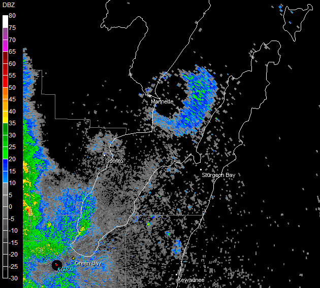
In this example, genuine rain and birds share one reflectivity display. The ring is not a circular rain shower. Notice its separation from the radar site near Green Bay, rather than identifying it from blue or green colors alone.
Other biological targets, including bats and insects, can also produce echoes. If you use dual-polarization data, a lower correlation coefficient can support an interpretation involving a less uniform mix of targets, but it is not a bird detector. Melting or mixed precipitation can lower it too. Timing, location, and the surrounding weather remain essential.
A ring around the radar can be melting snow
A bright band occurs when melting snow enhances reflectivity. Wet snowflakes can return a stronger echo than the precipitation above or below them. As a tilted beam sweeps around the radar, it can intersect that melting layer at a similar distance in many directions, producing a ring or partial ring.
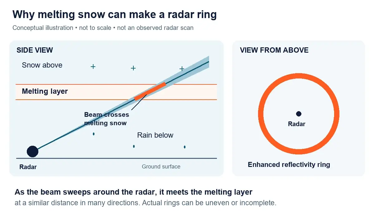
The NWS Jackson melting-layer examples show this effect in reflectivity and dual-polarization products. Changing the elevation angle can change where the beam meets the layer. The ring may be uneven or incomplete, and its surface precipitation type cannot be read from the ring alone. A bright band involves real precipitation, so do not dismiss it as equipment failure.
Ground clutter, beam bending, and display circles
Radar can detect terrain and structures as well as precipitation. Changes in the vertical temperature and moisture profile can bend the beam unusually far downward, allowing more ground targets to contribute echoes. This is one form of anomalous propagation. It often creates persistent patches, rather than a tidy expanding weather feature. The NWS explanation of radar limitations describes this beam behavior.
A smooth circular edge can also arise when software assembles information from different scans or radars. The details depend on the product. For example, the Hong Kong Observatory explains concentric rings in its three-dimensional radar product as a projection and sampling effect. That explanation should not be applied automatically to every ring in an ordinary reflectivity app.
A distance overlay is simpler still: it is a graphic drawn on the map, not an echo. Hiding the overlay may settle that case immediately. If a circle remains in the data, keep investigating rather than assuming every radar-centered pattern has the same cause.
Why spokes and missing wedges appear
A bright radial streak and a blank wedge are different clues. Radio interference can add a spoke of apparent echoes. Solar interference can briefly produce a streak when the antenna points toward the low sun near sunrise or sunset. The NWS Milwaukee radar guide includes a sun-spike example. An obstruction can instead weaken or remove returns behind it, leaving a persistent sector with less data.
Compare the same radar, product, and time in another display. If the feature disappears, display processing becomes a possibility. If it remains, the underlying observations may contain it. Neither result by itself names the cause, and an empty sector does not guarantee clear weather.
A hail spike is an important exception
A weak streak extending beyond a strong storm core, along the direction away from the radar, can be a three-body scatter spike, also called a hail spike. The displayed extension is an artifact caused by a more complicated signal path, but the parent storm may contain large hail. The NWS Louisville hail-spike example shows why “artifact” does not mean “harmless storm.” Do not use the spike to estimate hail size at your home.
What your home weather station can tell you
Your station measures conditions at one point near the ground. Radar samples a volume of air that may be well above it. Those measurements complement each other, but they are not interchangeable. A dry gauge alone cannot distinguish birds, clutter, precipitation evaporating aloft, or rain that simply missed your yard.
For a thin arc moving away from a thunderstorm, compare its passage time with your station’s recent history. A wind-direction shift, gust, and temperature drop occurring together can support an outflow-boundary interpretation. Check the timestamps and the station’s reporting interval, because the latest app value may lag the actual change. Use records collected automatically while you stay sheltered.
Our outflow-boundary guide explains those moving arcs in detail. If your main question is why the app shows rain while your gauge stays dry, use the radar-versus-ground-rain checklist. Do not recalibrate a rain gauge simply to make its total match a radar estimate.
A useful observation log records the radar site, scan time, product, apparent center, and station changes. Add whether the pattern persists when overlays are hidden or when you change radar sites. These specific comparisons make a much stronger record than writing only “strange radar ring,” even when the exact cause remains unresolved.
Common questions
Does a radar ring mean a tornado?
A ring alone does not establish rotation or a tornado. Birds, melting precipitation, outflow, and display effects can all create circular patterns. Follow official warnings without waiting for a particular shape on your app.
Why does a ring appear near sunrise?
Birds leaving a roost are one possibility, especially when the ring expands from a small non-radar location. Sunrise also matters for solar interference, which more typically produces a radial streak. Compare the shape, origin, and motion together.
Can I identify the cause without velocity or dual-pol data?
You can narrow the possibilities using the radar location, product name, scan time, overlays, and loop. Nearby observations and official explanations help. Some cases require specialist analysis, so leave the identification uncertain when those checks do not agree.
Sources checked September 25, 2026. Primary references are linked beside the explanations they support. The bird-ring image is credited to NOAA/NWS Green Bay, and the melting-layer diagram is a conceptual WXObservation illustration.