
Weather radar field guide
Thin Line on Weather Radar: Outflow Boundaries Explained
That faint arc ahead of a thunderstorm may mark a gust front. Learn what radar is detecting, how to recognize an outflow boundary, and what a passing line can mean at your location.
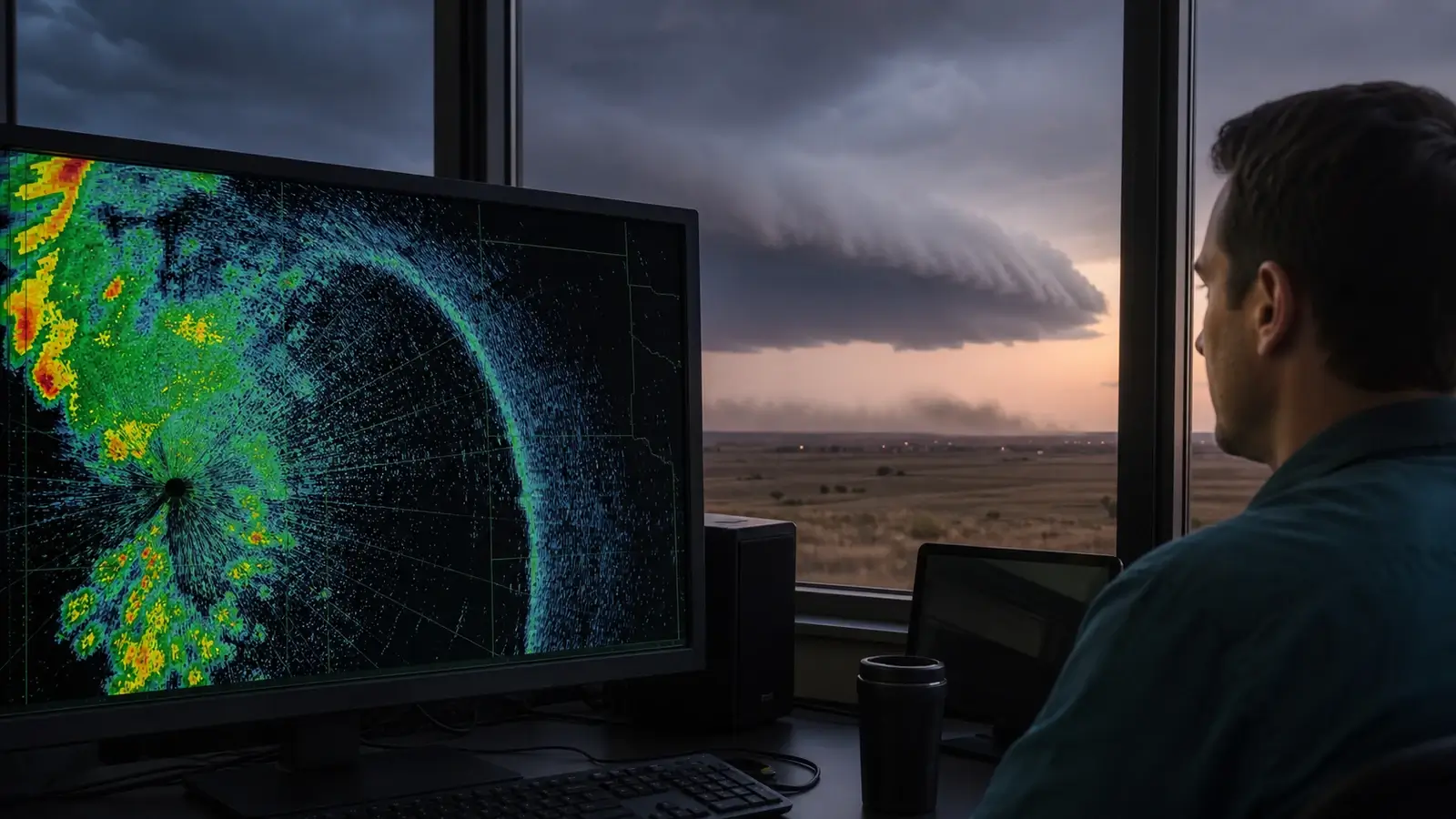
Quick answer
A thin line on weather radar is often an outflow boundary when it spreads away from thunderstorms. This is the leading edge of storm-cooled air, also called a gust front. Radar can detect insects and other small targets concentrated along the boundary, as well as sharp changes in the air’s refractive properties. The line may arrive before any rain. Its color does not tell you how strong the surface gust will be.
A narrow stripe of weak radar echoes can be easy to dismiss when the heavy rain is still far away. Sometimes that stripe marks a real change in the air at ground level. The useful question is whether its motion and surroundings fit a thunderstorm outflow boundary, rather than whether it looks like a perfect line.
What is a radar fine line?
A fine line is a narrow band of radar echoes associated with a boundary in the air. Outflow is one possible cause. Cold fronts, sea-breeze fronts, and drylines can also produce fine lines, so the shape alone does not identify the boundary.
The American Meteorological Society’s definition identifies two important contributors: insects and insect-eating birds gathered along the boundary, and sharp gradients in the atmosphere’s refractive index, which describes how the air affects radio waves. The radar is detecting scatterers and changes in the air’s properties, rather than directly seeing the wind itself.
Reflectivity describes radar echo strength. Rain can produce an echo, but an echo does not prove rain is reaching the ground. A faint outflow line is therefore neither a rainfall estimate nor a surface wind-speed scale. Our reflectivity and velocity guide explains what each radar product measures.
How an outflow boundary forms
Thunderstorm downdrafts carry air downward. Evaporation of precipitation helps cool that air, while falling precipitation can also drag air downward. When the cooler, denser air reaches the ground, it spreads outward beneath warmer surrounding air. Its advancing edge is the outflow boundary.
Air converges and rises along that edge, concentrating small airborne targets. The boundary may move ahead of the rain, curve around a storm, or keep traveling after the original storm weakens. The NWS outflow-boundary definition notes that some boundaries persist for a day or more. Many are shorter-lived, and their visibility on radar varies.
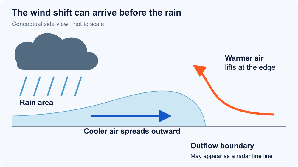
If moisture and cloud formation make that leading edge visible, a shelf cloud may accompany it. The cloud is not required for a radar fine line, and a shelf cloud is not the same as a rotating wall cloud. See shelf clouds versus wall clouds for the visual differences.
A real radar example: an expanding outflow ring
This NWS Hastings radar image shows an outflow boundary at 4:42 p.m. CDT on June 24, 2009, over southern Nebraska and northern Kansas. Look for the large, nearly circular blue-green outline surrounding the brighter storm echoes. The circle spans about 50 miles in diameter. That is its size in this image, not a wind speed.
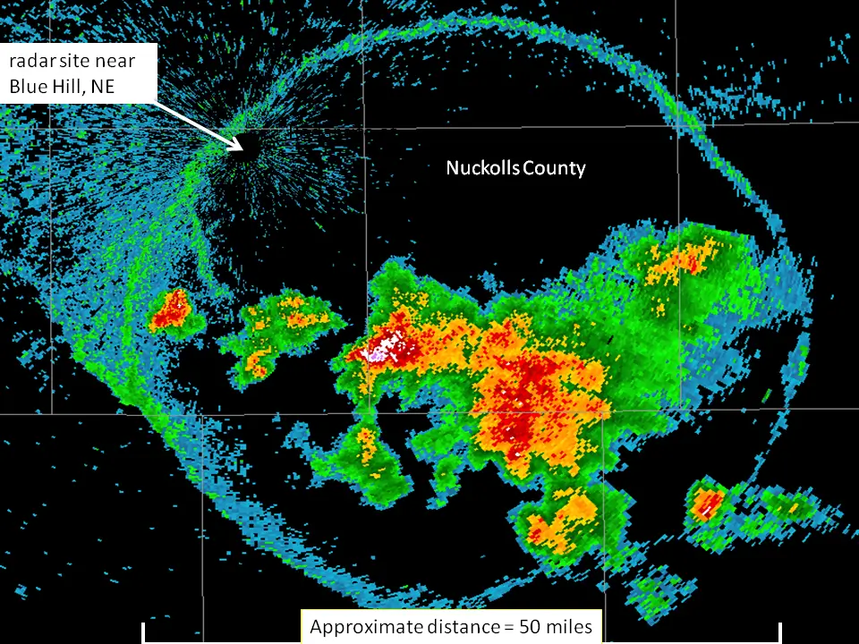
Notice that the radar site, labeled near the upper left, is not at the center of the circle. This is a boundary spreading from thunderstorms, not simply a circle drawn around the radar. The NWS account documents additional storms developing along the boundary as it expanded. This particular case illustrates what can happen, rather than what every fine line will do.
Motion is easier to judge in a loop. The NWS Wilmington September 10, 2016 radar animation shows another outflow boundary racing ahead of storms, with both reflectivity and velocity views. Use the animation to compare the moving line with the rain behind it.
Five checks before calling it outflow
- Loop several scans. Look for a line expanding or moving away from current or earlier thunderstorms. One still image rarely establishes its origin.
- Use a nearby radar and its lowest available tilt. If your app offers single-radar reflectivity, start there. A broad mosaic or composite can hide a shallow, weak boundary. Radar samples higher above the ground farther from the site and may miss the outflow’s shallow edge.
- Compare velocity at a similar time. A shift in motion toward or away from the radar can support the interpretation. Doppler velocity measures the component along the radar beam. Motion mostly across the beam may look weak, and a weak signal does not rule out an outflow boundary.
- Check nearby surface observations. A wind shift with a gust and a temperature drop can support a boundary passage. Compare timestamps and several nearby stations when available. A single station may miss a narrow or uneven feature.
- Check the wider weather pattern. A line tied to the coast may be a sea breeze. A broader frontal boundary needs regional weather-map context. Fixed ground echoes or a feature that appears only in one app deserve an artifact check.
Use these clues together. The NWS Melbourne radar guide demonstrates how radar can reveal sea-breeze and thunderstorm-outflow boundaries. It also explains why beam height and non-precipitation targets limit a simple “colored area means rain” reading. Our guide to radar echoes without rain at your location covers the broader mismatch.
For circles centered on a radar or narrow radial streaks, compare the patterns in our radar rings and spokes guide.
What you may notice when it passes
Outflow strength varies. A boundary may bring a modest breeze, or it may carry damaging straight-line wind. Rain can arrive later, miss your location, or never reach it. Use the following changes as clues in safely collected observations, not as a checklist that must be complete.
| Observation | Possible change | What it cannot prove |
|---|---|---|
| Wind | A direction shift and a brief or sustained increase in speed. | A gust alone does not identify its cause or make it a tornado. |
| Temperature | A drop as cooler storm air arrives. | The drop is not equally strong at every station. |
| Pressure | A rise may accompany the cooler outflow. | Pressure alone cannot confirm a gust front. |
| Rainfall | Rain may follow, or the boundary may pass without rain. | A dry rain gauge does not rule out a real boundary. |
For your observation log, record the passage time, wind direction, gust, temperature trend, and whether rain followed. Compare nearby station records and the radar loop afterward. An isolated sensor spike deserves investigation, but should not automatically be dismissed as an error. Related changes and independent observations make the interpretation stronger.
When comparing the wind change, distinguish the recent gust from an average or the day's maximum. Our wind gust versus sustained wind guide explains which time windows to match.
Outflow is a broader term than microburst. A microburst is a localized, intense downdraft and its damaging surface outflow. A long radar fine line does not by itself diagnose one. Our microburst and tornado comparison explains the distinction without relying on damage direction alone.
Will new storms form along the line?
An outflow boundary can lift warm, moist air. New thunderstorms become possible if that lift helps air rise through a sufficiently unstable atmosphere. Boundaries that meet can focus stronger lifting, but storm formation is not guaranteed. NOAA’s thunderstorm-ingredients explainer describes the required moisture, instability, and lift.
A stable layer can prevent sustained rising motion. The air may also be too dry, or the advancing cool air may undercut an existing storm’s supply of warm inflow. A visible fine line is a place to monitor on the radar loop and forecast discussion, rather than a promise of new rain or severe weather.
Common questions
Does a radar fine line mean rain is coming?
Rain is not guaranteed. An outflow boundary can travel ahead of the rain or away from a weakening storm. Check the precipitation behind it, its motion, and your local forecast rather than treating the line as a rain forecast.
Can the line bring strong wind even when its colors are faint?
Strong surface gusts are possible with weak reflectivity. Echo strength depends on what the radar detects, while the gust depends on the moving air. Follow warnings and do not use the reflectivity color to judge whether it is safe outside.
Does a curved or circular line mean a tornado?
A curved line does not establish rotation or a tornado. Outflow can spread in an arc or ring as cooler air moves outward. Tornado assessment requires other evidence, and official warnings take priority over an informal reading of the shape.
Why can I see it in one radar app but not another?
Apps may use different radar sites, tilts, update times, mosaics, filters, or color scales. Compare the same site, product, and timestamp if those controls are available. Even then, a shallow boundary may be too weak or too far below the beam to appear clearly.
Sources checked September 12, 2026 against the AMS definition and the NOAA/NWS references linked above. The cross-section is an explanatory illustration. The radar case image is credited to NOAA/NWS Hastings.