
Why and How to Upload Weather Station Data Online
Use remote monitoring, history, alerts, public maps, citizen science, and quality checks—without overlooking compatibility, metadata, or privacy.
Six useful reasons to put station data online
1Monitor conditions remotely
Check your home, garden, cabin, business, or equipment site from a phone or browser without being beside the console.
2Build a history
Graphs and exports reveal seasonal patterns, storm totals, daily extremes, equipment outages, and gradual sensor changes.
3Use alerts and automations
Supported platforms can notify you of temperature, wind, rainfall, humidity, or connectivity conditions. Treat one consumer sensor as information—not a sole life-safety system.
4Share with family or neighbors
A public or private dashboard can provide genuinely local observations for people near your station.
5Contribute to a network
Well-sited stations can support citizen-science and public data systems. NWS describes CWOP as a volunteer network whose observations are used by forecasters, emergency managers, fire personnel, universities, and others.
6Spot quality problems
Comparing trends and viewing long records can expose stuck wind sensors, blocked rain gauges, heat bias, wrong elevation, or data gaps.
Choose a destination by purpose
| Destination type | Best for | Typical access | Important limit |
|---|---|---|---|
| Manufacturer cloud | Setup, app dashboards, device management, alerts, and ecosystem sensors. | Direct from a compatible console/gateway. | Features, exports, retention, and sharing depend on the manufacturer. |
| Public PWS map | Hyperlocal public conditions, community comparison, and shareable station pages. | Direct upload or supported gateway/software. | Compatibility and data-quality handling vary by network. |
| CWOP | Volunteer contribution that can flow into NOAA’s MADIS system. | Compatible software, hardware gateway, or supported service. | Accurate coordinates, elevation, siting, quality, and reliable uploads matter. |
| Local / self-hosted | Private history, home automation, local dashboards, APIs, or custom analysis. | Local network, software, database, or automation platform. | Requires more technical setup, security, backups, and maintenance. |
Current upload paths to check first
The first table helps you choose a destination type. Once you know the purpose, use the service-specific table below to confirm the account, hardware or software path, and post-connection checks.
| Service | Usually required | Best starting point | Verify after connection |
|---|---|---|---|
| Weather Underground | A registered PWS station ID and key plus a console, gateway, app, or uploader that supports WU. | Weather Underground PWS overview | Station page, update time, units, coordinates, and rain/wind values. |
| Windy | A Windy station record and API key, or a device/software path listed in the current documentation. | Windy PWS documentation | Station ID, timestamp, elevation, pressure, wind direction, and upload interval. |
| CWOP / MADIS path | CWOP registration, an assigned station identifier, and compatible upload software, gateway, or forwarding service. | NWS CWOP guidance | Coordinates, elevation, siting, uptime, and data-quality feedback. |
| AmbientWeather.net | A compatible Ambient Weather console or gateway registered to an AmbientWeather.net account. | Ambient Weather network support | Device status, sharing preference, sensor list, and any additional network settings. |
| WeatherLink | Compatible Davis hardware and a WeatherLink account, public sharing and API access are separate choices. | WeatherLink | Station visibility, archive interval, sensor availability, and correct station metadata. |
| Tempest | A configured Tempest station and hub, public web sharing is controlled in the station settings. | Tempest sharing guidance | Public/private setting, station page, observation freshness, and location privacy. |
Read the personal weather station network guide for a current comparison of destination types and connection methods.
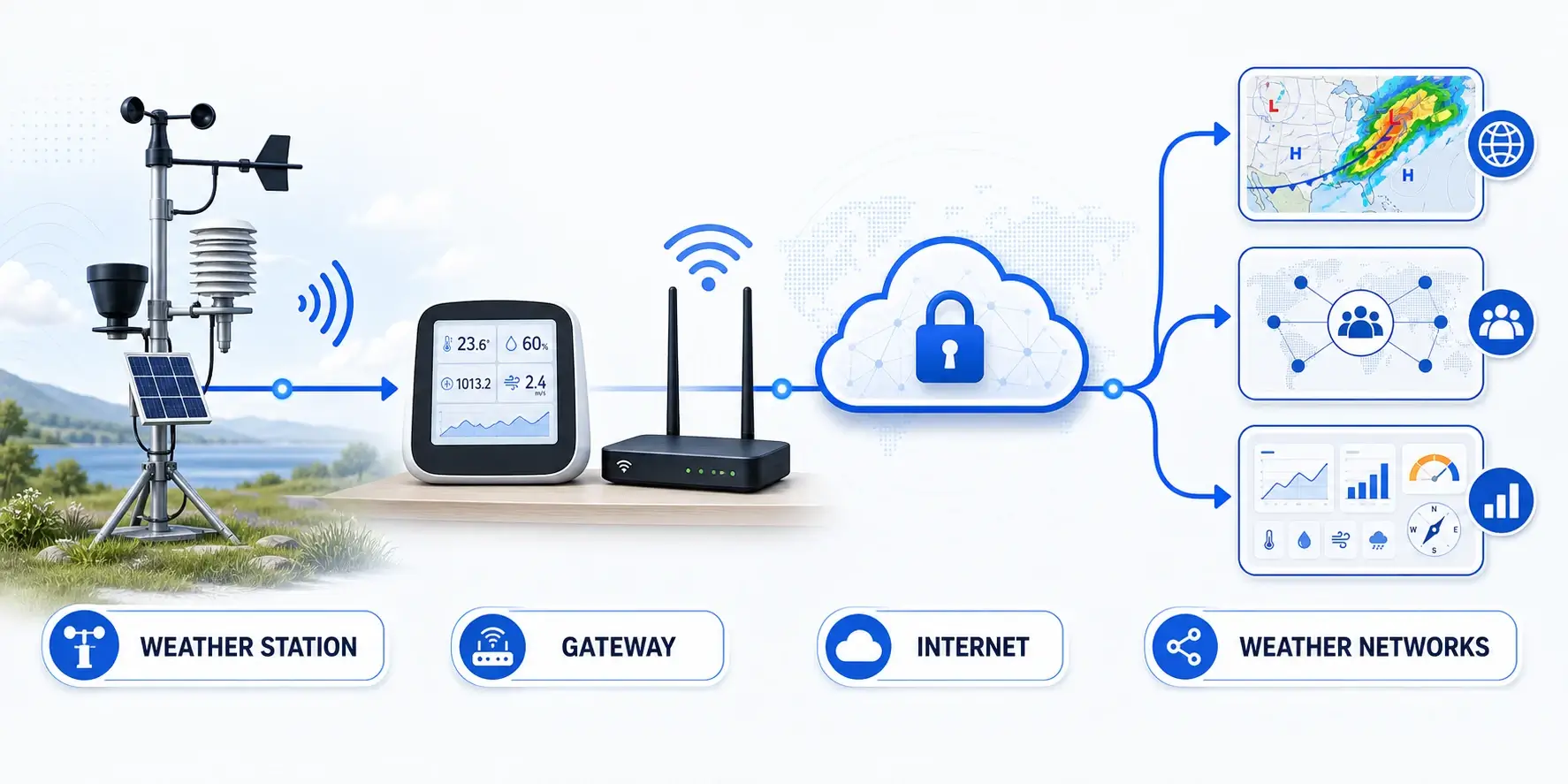
How weather data reaches the internet
Sensors
Observe temperature, humidity, pressure, wind, rain, and optional variables.
Console / gateway
Receives the sensor radio or cable signal and formats data.
Router / computer
Provides internet access or runs upload software when required.
Service
Stores, graphs, shares, or forwards observations.
People and tools
View dashboards, maps, alerts, APIs, or quality reports.
Choose a primary record and a backup path
Decide which destination will be your authoritative long-term record before enabling several uploads. A manufacturer cloud is often easiest for setup and remote access, while a community network or self-hosted database may offer different history, export, or sharing options. Write down which system owns the station profile, time zone, elevation, and calibration settings so the same observation is not interpreted differently in each service.
If the hardware supports more than one destination, add the second path only after the first is stable. Compare timestamps and totals for several days, then document credentials, update intervals, and any privacy offset. Multiple destinations can improve resilience, but they also create more places to troubleshoot when a router, gateway, password, firmware update, or service policy changes.
Set up a reliable upload
1Validate the station first
Correct installation, level the rain collector, clean sensors, confirm units and time, and investigate obvious biases before sharing.
2Choose the destination
Decide whether you need a private manufacturer dashboard, public map, CWOP contribution, local control, or more than one path.
3Create the station record
Enter latitude/longitude, ground elevation, time zone, station type, and requested metadata carefully. Do not confuse ground elevation with sensor height.
4Configure credentials safely
Enter station IDs, keys, or tokens only in the supported device/app/software fields. Do not publish private keys in screenshots or webpages.
5Verify the first observations
Check timestamp, units, coordinates, pressure interpretation, wind direction, rain total, and update interval on the destination.
6Monitor quality and uptime
Review gaps and unrealistic values, keep firmware and service details documented, and test after battery, router, or equipment changes.
Data quality, privacy, and expectations
Coordinates and elevation matter
Bad location metadata can make good measurements misleading and can distort pressure calculations or station-map placement.
Public maps can reveal a site
Review each service’s public fields and privacy options. A station name, exact coordinates, photos, and profile can identify a home.
Networks are not identical
Upload frequency, automated checks, suppression rules, history, APIs, and redistribution differ. Confirm the current service policy.
- Use the installation guide and accuracy guide before publishing questionable readings.
- Keep a maintenance log and investigate abrupt data changes.
- Do not present one home station as an official warning or certified record.
- Use NWS alerts and official emergency information for hazardous-weather decisions.
Common upload problems
| Problem | Check first |
|---|---|
| Station shows offline | Gateway/console power, sensor link, Wi-Fi/Ethernet, router, service status, credentials, and timestamp. |
| Wrong map location | Latitude/longitude order, decimal signs, privacy offset, saved station profile. |
| Pressure looks wrong | Ground elevation, station versus sea-level pressure, units, and the service’s expected field. |
| Duplicate station | Old station ID, replacement hardware registration, multiple uploader configurations. |
| One network works and another does not | Destination-specific credentials, supported protocol, upload interval, firmware, and service requirements. |
| Missing history | Retention policy, console memory, uploader outage, subscription/export settings, and service-side gaps. |
FAQ
Can I upload to more than one weather network?
Often, yes, but it depends on the station, gateway, firmware, and software. Some consoles support several destinations directly. Others need a manufacturer relay, local software, or a compatible third-party gateway.
Does uploading to Weather Underground send data to NOAA?
Do not assume that one public network automatically forwards your data into every government system. CWOP is a documented path into NOAA MADIS. Treat each destination as separate unless current official documentation says otherwise.
Do I need a computer running all the time?
That is not always true. Many current consoles and gateways upload directly. Older or more customizable systems may use always-on software or a small network device.
Is public weather-station data accurate?
Quality varies with equipment, siting, maintenance, metadata, and network checks. Compare multiple stations and look for consistency rather than trusting a map marker automatically.
Sources and further reading
These official and network references explain how personal-station data is shared, checked, and used by public weather services.
NWS Citizen Weather Observer Program — Official overview of contributing personal weather-station data.
Weather Underground PWS overview — Network instructions for connecting and sharing a personal station.
OpenWeather stations — Documentation for contributing station observations to OpenWeather.
Windy station API documentation — Technical documentation for sending station data to Windy.