
Damaging-wind field guide
Microburst vs. Tornado: Damage, Wind, and Radar Clues
A microburst descends and spreads wind outward, a tornado rotates around a vertical axis. Damage direction and radar help, but reliable classification requires the full storm context and often an official survey.
Quick answer
A microburst is a convective downdraft whose surface outflow affects an area less than 2.5 miles wide and whose peak winds last less than five minutes. A tornado is a violently rotating column of air extending from a thunderstorm to the ground. Microburst damage often diverges away from a center, while tornado damage can converge, cross, and rotate along a path. Real damage is messy, so radar, eyewitness reports, timing, debris, and an official survey matter more than one tree or roof.
Both microbursts and tornadoes can snap trees, roll vehicles, peel roofs, and produce winds strong enough to cause severe damage. Afterward, people naturally try to identify the cause from the scene. The most tempting rule—trees outward means microburst, trees inward means tornado—is useful as a starting hypothesis but unreliable as a verdict.
Wind interacts with terrain, structures, weak trees, and debris. Neither event produces a textbook damage field at every location. Good diagnosis follows the airflow from storm scale to individual damage indicators and preserves uncertainty until the evidence agrees.
The fundamental airflow difference
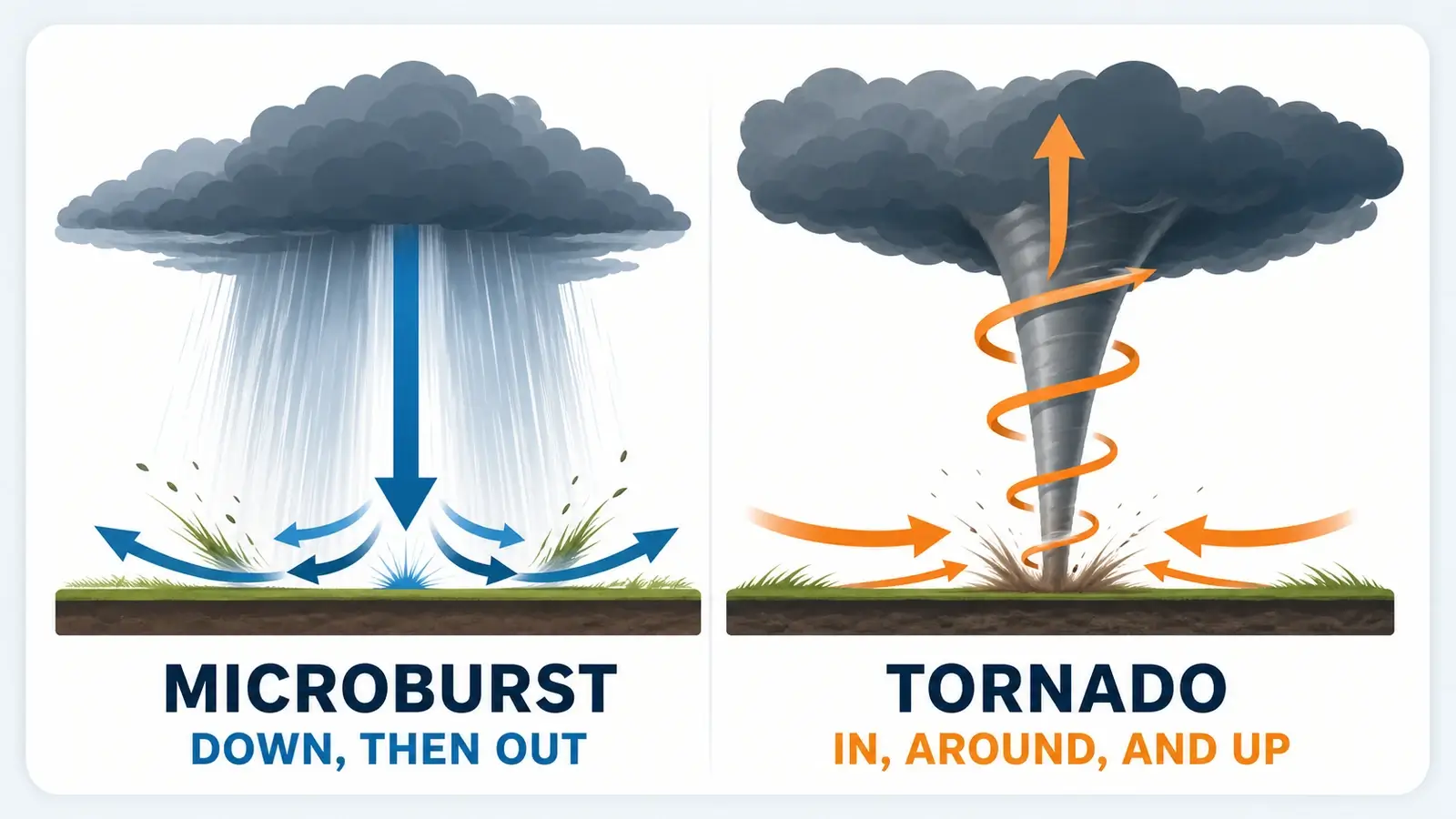
A microburst begins as a concentrated downdraft. Precipitation loading, melting, and evaporation can cool and accelerate descending air. When the column reaches the surface, it spreads horizontally in all available directions, producing a burst of divergent straight-line wind. The strongest flow may occur in one or several lobes rather than in a perfectly symmetric circle.
A tornado is dominated by rotation around a vertical axis. Air flows inward near the ground, accelerates as it turns, and rises within the circulation. The tornado also moves with its parent storm, so the resulting path combines rotational wind with forward motion. One side can experience much stronger ground-relative wind than the other. This inflow-versus-outflow contrast is also useful in the field, as explained in our shelf cloud versus wall cloud guide.
A downburst is the broader family, and a microburst is its small, short-lived member. The National Weather Service glossary defines a microburst by an affected outflow area less than 2.5 miles wide and peak winds lasting less than five minutes. Larger downbursts and repeated downbursts can help drive broader systems, as explained in our derecho, bow echo, and squall line guide.
Wet microburst versus dry microburst
A wet microburst reaches the ground with substantial rain. A descending rain shaft may appear to spread outward at the base, followed by intense wind and a rapid temperature drop. Heavy precipitation can hide the worst wind and reduce visibility, so the visual rain curtain should not be treated as a safe boundary.
A dry microburst produces little measurable rain at the ground because precipitation falls into a deep dry layer and largely evaporates. That evaporation cools the air and strengthens its descent. Blowing dust may be the clearest surface sign. Dry microbursts are especially important in arid regions and aviation because severe wind can arrive beneath virga.
The categories form a continuum. A storm can be relatively dry at one location and wet a few miles away. Both types spread damaging outflow, and neither can be judged solely from how dark the cloud looks.
What damage direction can—and cannot—tell you
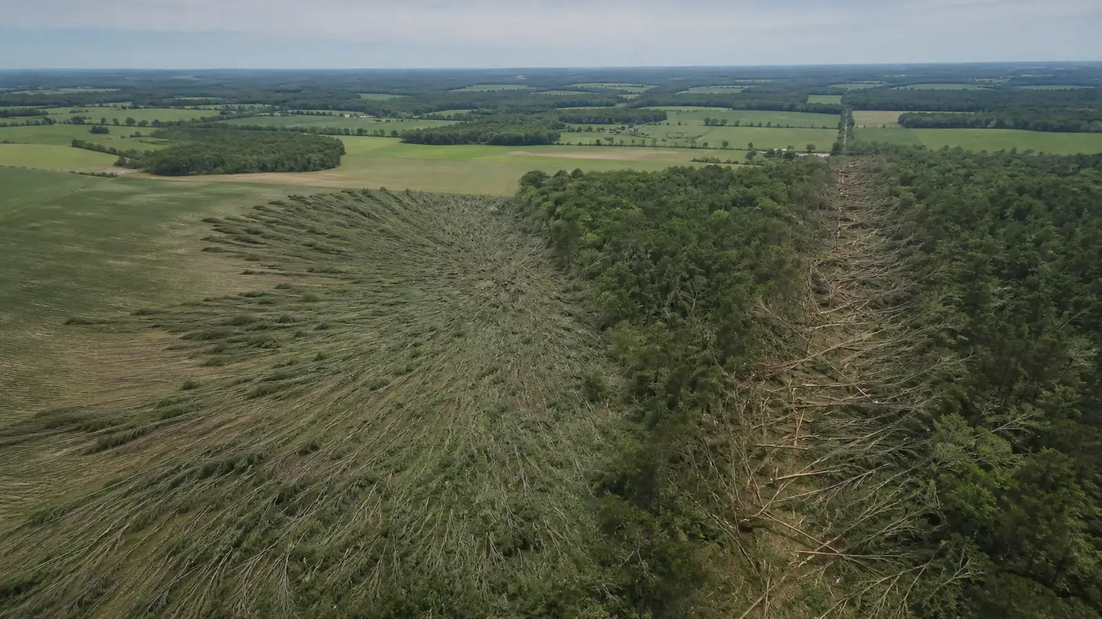
Surveyors map the orientation and sequence of many damage indicators. A fan-shaped field of trees falling away from a central impact area supports divergent outflow. Convergent fall directions, crosswise debris, and a narrow continuous path support tornadic rotation. Marks on multiple sides of structures and lightweight debris transported across the path add context.
One fallen tree is weak evidence. Root condition, species, slope, nearby buildings, prior damage, and the direction of least resistance can determine how it falls. Rows of trees can domino, making several trunks point the same way even when the initiating wind varied. Cleanup can erase clues, and social images rarely show exact location or orientation.
Intensity is not a discriminator. A powerful microburst can produce damage comparable to some tornadoes in a localized area. Conversely, a weak tornado may leave a subtle path. The Enhanced Fujita scale estimates tornado wind from damage. It is not a universal scale for labeling every thunderstorm-wind event.
Radar clues for divergence and rotation
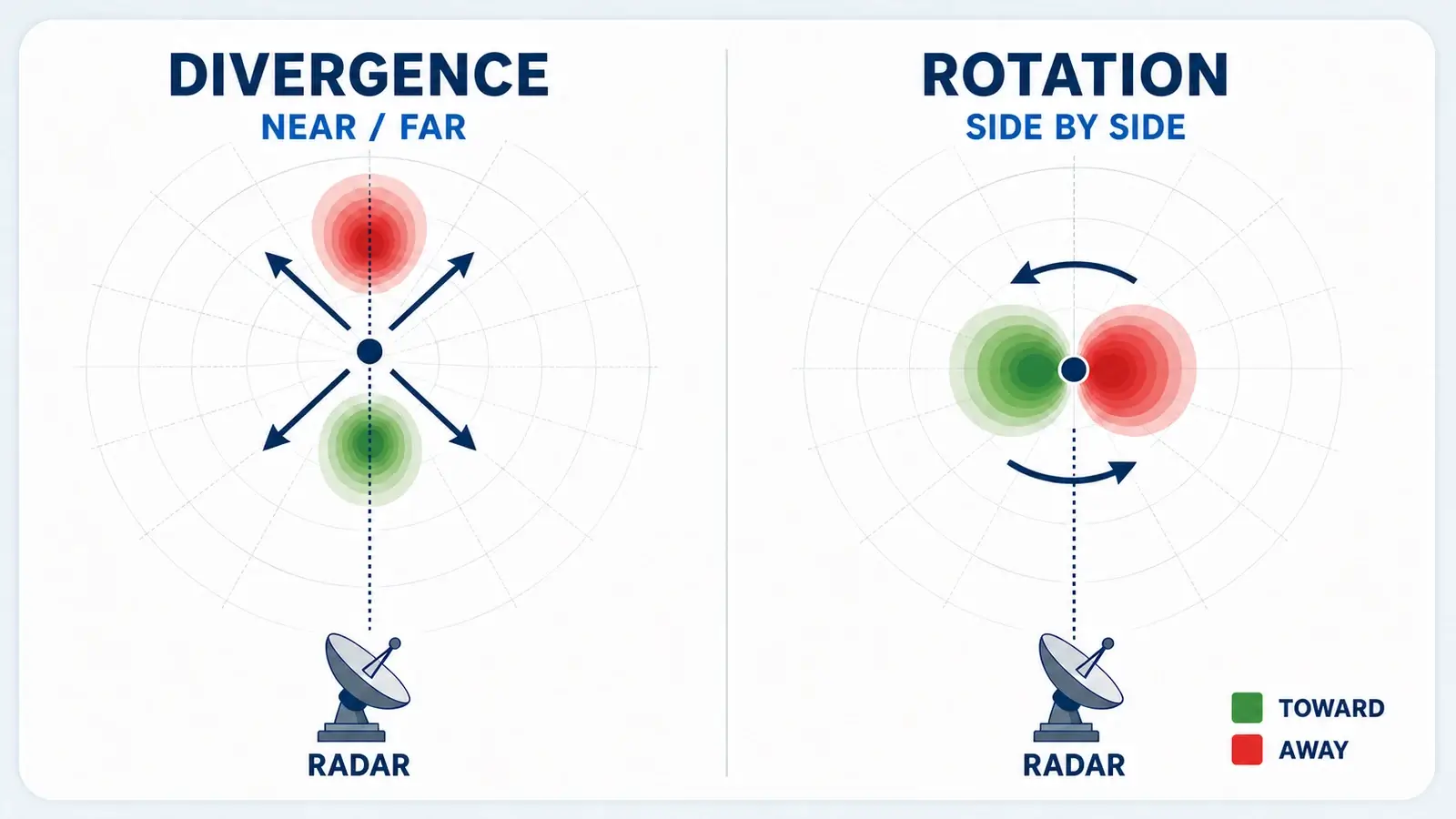
When viewing geometry is favorable, velocity data can show a low-level divergence signature as a microburst reaches the ground. One side of the outflow may move toward the radar while the other moves away. Reflectivity can show a strong precipitation core or a bowing segment, but those shapes do not establish that a microburst reached the surface. Forecasters may also look for midlevel convergence before the burst, yet microbursts are so brief that some occur between radar scans.
A tornado-producing circulation may appear as a tight velocity couplet, with winds moving toward and away from the radar adjacent to one another. Storm-relative velocity can make rotation easier to see by subtracting estimated storm motion. Dual-polarization correlation coefficient may reveal lofted debris after a tornado is producing damage, but that signature can be weak or absent with weaker tornadoes or storms far from the radar. Forecasters rely on reflectivity and velocity structure and trends rather than waiting for debris.
Radar has important blind spots. It samples motion along the beam rather than the full wind vector, and the beam rises with distance. Low-level microbursts and tornadoes can occur beneath what a distant radar sees. Velocity can also fold or contain non-weather targets. Our guide to why radar can show rain when none reaches the ground explains how beam height and evaporation can separate a radar echo from surface conditions.
What an observer may experience
A microburst often arrives as a sudden blast, an abrupt wind shift, a sharp temperature drop, heavy rain or blowing dust, and rapidly changing visibility. Wind may reverse as the divergent burst crosses the site. The most intense period is brief, but the parent storm and surrounding outflow can continue much longer.
A tornado may be preceded by inflow, changing wind, a lowering or funnel, power flashes, or a debris cloud, yet many are rain-wrapped or occur at night. Sound is unreliable and can be masked by hail and wind. The absence of a visible funnel does not prove that circulation is not on the ground.
Do not watch from a doorway to decide which one is coming. Severe thunderstorm warnings can include winds capable of major damage, and tornado warnings require immediate tornado shelter. The correct protective action overlaps: sturdy building, interior room, away from windows. A basement or purpose-built safe room provides additional tornado protection.
How to evaluate the event afterward
Begin with the warning archive, radar loop, nearby station data, and exact times. Photograph damage before moving it when safe, noting the camera direction and location. Document the orientation of many indicators rather than selecting only the examples that support a preferred answer. Never enter unstable structures or approach downed power lines.
Look for an official National Weather Service public information statement or storm survey. Survey teams combine radar, eyewitness accounts, drone or aerial imagery, structural engineering clues, and a mapped path. Their conclusion may be tornado, downburst, straight-line wind, or indeterminate when evidence is insufficient.
Uncertainty is a scientifically valid result. “Damage was caused by severe thunderstorm wind. Available evidence does not establish a tornado” communicates more truth than attaching a dramatic label. For immediate decisions, the event name matters less than respecting every destructive-wind warning.
Frequently asked questions
Can a microburst be stronger than a tornado?
A microburst can produce extreme localized wind and damage comparable to some tornadoes. Wind speed or severity alone does not identify the airflow mechanism.
How long does a microburst last?
By National Weather Service definition, peak winds in a microburst last less than five minutes, though the surrounding thunderstorm wind and rain can persist longer.
What is the difference between a wet and dry microburst?
A wet microburst brings substantial rain to the surface. In a dry microburst, much of the precipitation evaporates before reaching the ground, so blowing dust or virga may accompany the wind.
Do trees always fall inward in a tornado?
The answer is no. Tornado motion, terrain, structures, tree condition, and debris interactions can create mixed or one-directional fall. Surveyors examine many indicators across the entire path.
Sources and further reading
- NOAA National Weather Service glossary: Microburst
- NOAA National Weather Service glossary: Tornado
- National Weather Service Birmingham: Microburst formation and radar clues
- National Weather Service Binghamton: How damage surveys distinguish wind events
- National Weather Service Louisville: Tornado velocity and debris signatures
- National Weather Service Melbourne: Severe-wind safety
- National Weather Service: What to do during a tornado
Fact-checked against current NOAA and National Weather Service guidance on August 23, 2026.